Finding scale calculator. Scale and its application. What is scale
We are surrounded by many objects, small and large. We do not think about the fact that each item goes through various stages of creation. One of the stages in the creation process is the layout. The layout can be of different sizes and different scales in relation to the original.
Models of many products are made in full size. However, many layouts are made X times smaller than the original. Imagine your dream home. Let's say that its length is 12 m. To imagine the appearance of the house, you need to build its layout. Will you be building a life size layout? Of course not, it's stupid and expensive.
You will build the layout in a reduced form. In order to maintain proportions, you need to divide each size several times. The ratio of the size of the layout and the original is called the scale. If your house is 12 m long, then at a scale of 1:100, the length of the layout will be 120 mm. This is how each size is calculated.
Will a 120 mm long layout suit you? I'm sure not. First, it will be inconspicuous. Secondly, you will need to have the skills of Lefty, who shod a flea. Therefore, it is worth thinking about a larger layout. The optimal layout of the layout of such a house will be on a scale of 1:25. At this scale, the length of the model of the house will be 480 mm. A layout of this size will look good and be easy to build.
We have analyzed the moment when a product and a product layout are created independently. Let's consider another example. You leaf through a magazine and find a beautiful house. You only have a photograph or a small drawing in three or four projections. Do you want to build such a house! Decided!
To better represent the future house from the picture, you build a layout. How, then, to calculate the scale? Everything is simple. You are looking for more information in the description of the house. Surely, there is at least a mention of the length of the facade. It's enough. You take a ruler and measure the length of the facade in the picture. For example, the front length in the figure is 60 mm. In the description of the house, you found the length of the facade in actual size. For example, the length of the facade of the house is 11.7 m. You have all the data you are looking for.
Convert 11.7 meters to millimeters. 11.7 m = 11700 mm. Divide 11700 by 60. We got the number 195. Thus, your picture has a scale of 1:195. The picture is 195 times smaller than the original. Go ahead. You determine that the length of the facade of the future layout will be the same 480 mm. When dividing 480 by 60, we get the number 8. You will need to multiply all the sizes from the image by a factor of 8. Now it remains to calculate what scale the layout will have in relation to the original. If you multiply the dimensions from the image by 8, then you must divide by 8 the original scale. Thus, 195:8=24.375. The scale of your layout with a facade length of 480 mm, in relation to the original will be as follows - 1:24.375.
Now you just have to do a little practice with a ruler and a calculator. Very soon you will become a scaling expert.
This lesson is about the method of how to change the scale in AutoCAD using the quick calculator utilities.
This method is universal and allows you to determine and change the scale in AutoCAD of any objects, even without knowing their size. This is useful when pasting bitmaps or other underlays.
We will also consider the standard ways to change the scale in AutoCAD and one of the sub-options is the "Reference line".
Suppose we have some kind of drawing of a building reconstruction plan and a scanned image that shows a summary network plan and needs to be inserted into AutoCAD. Next, we need to scale our picture so that the dimensions become true and combine the building in the drawing with the building in the image. Go to the Insert tab, then Attach, in the window that appears, find our picture, click Open and OK. We indicate the insertion point away from our drawing, indicate the scale 1 and press Enter. Done, the picture is inserted, but as we can see it is not the size it should be, so first we will visually enlarge it so that it is convenient to work. Now we need to scale the loaded image in such a way that the building in the picture matches the size of the building in our drawing. To begin with, using an example of an arbitrary object, let's consider how the Scale tool works. Go to the Home tab and in the Editing tools select Scale. Next, select our object, press Enter and select the base point. The base point is the point about which the object will change. Next, on the command line, specify the scale factor, i.e. if we want to increase our object three times, we set 3 accordingly. To reduce the object, let's say ten times, you must specify 0.1 and note that fractional numbers on the command line are entered through a dot , not separated by commas. This is how the Default Scale tool works. Now, in order to find out the scale factor, we need to measure one and the same side of the object in the picture and in the drawing, then divide one size by another. But we will do otherwise. Select the Scale tool, select the image you want to scale and press Enter. For the base point, select absolutely any angle, then click on the right mouse button and select Quick Calculator. And now we can determine the scale factor in a quick calculator. To do this, we select the Distance between two points utility, specify the distance between two points of the source object, then click on the Divide button on the calculator, again select the Distance between two points utility and indicate the distance in the picture corresponding to that indicated in the drawing. Now pressing Enter, we get the scale factor, then Apply and again Enter, ready. And the last thing left to do is to position the building from the drawing to the picture with the correct angle of rotation. So, select the object that we will position, then on the Home tab, on the Edit panel, find and select the Alignment tool. Now, with the left mouse button, we indicate a point on the object that we are positioning and a point on the figure, in the place where we position our object. It will suffice for us to indicate three points. Everything is ready, but our object is under the substrate. To send the matte to the back, we need to select it, on the Home tab, on the Editing panel, click the icon and select Send to Back. This is how we scaled our picture and positioned our object on the master plan of networks.
On any geographical map, you can see approximately the following inscription: "Scale 1: 100,000." Traditionally, the first number is 1, and the second can vary. If there is no inscription, then there is certainly a tiny ruler, divided into equal segments, or a nomogram. These signs indicate the ratio of the size of an object on a map or plan to its actual size.
You will need
- Roulette or compasses
- Ruler
Instruction
1. If you have a plan on which different objects are fairly accurately plotted, and you need to find out at what scale this plan was made, start with measurements. Select an object, one that is nearby. Measure it on the plan and write down the results.
2. Measure the actual object. Use a tape measure for this. In order to avoid mistakes, make a peg and hook a tape measure loop on it. Drive a peg into the ground so that the zero mark of the tape measure is on the tier of the starting point of the length or width of the object.
3. Determine the scale. It is more convenient for everyone to write it down in numbers. Write down the size of the object on the plan, after that - the one that turned out when measured on the territory. Let's say you have a barn 5 meters long on the plan occupies 2.5 cm. Convert meters to centimeters. That is, it turns out that you have 500 cm in 2.5 cm. Calculate how many centimeters of territory are contained in 1 cm on the plan. To do this, divide the larger number by the smaller one. It turns out 2.5:500 = 1:200, that is, 1 cm on the plan corresponds to 2 m on the territory.
4. In order to determine the scale more correctly, take several measurements. Let's say measure the barn on the site and the distance from the gate to the pond. The plans are different, and the dimensions of one or another object can be applied unsatisfactorily correctly. If there are discrepancies, make another frosted. The image of the object, the one that does not correspond to the other two, correct on the plan.
Scale is a numerical designation of parameters related to real objects that are unthinkable to depict in natural size. The figure applies their layouts.

Instruction
1. The scale is written in several ways, say, numerically - 1: 1000000. The size ratio can also be indicated in this form: 1 cm 10 km is a named scale. The linear display method is shown by a ticked line.
2. When considering scale in relation to cartography, the appearance of a particular map will depend on the ratios used. The larger it is, the more detailed the area will be depicted. The detail is also influenced by the nature of the territory, which is sparsely inhabited, say, easier to depict. Maps are large, medium and small scale. Large-scale maps are when 1 cm is from 100 to 2000 meters, medium-scale maps are 1 cm to 10 km, small-scale maps are 1 cm more than 10 km.
3. Scale matters in photography as well. With the help of lenses, photographers change the size from hefty small to hefty large. The methodology of the metamorphosis of scale depends on the specifics of the surveys. If these are small objects, say, insects, the scale increases, if they are huge, it decreases.
4. The representation is also used in many sciences. In mathematics it is the ratio of numbers, in programming it is the scale of time, in astronomy it is the scale of the universe. The meaning of the word is also used in the construction industry.
5. Firms are distinguished by the scale of their activities. There are, say, territorial organizations, but there are also federal tiers. Different in scale and people. True, not from a physical point of view, there is a psychological representation of the “scale of the figure”. This refers to human qualities, goals and results of activities.
Related videos
Note!
The size of a reduced object is relative to its natural size. The distance between objects can be changed by several centimeters, meters, kilometers. The scale of reality changes a lot, but all parameters must remain proportional. If you do not respect the proportions, it will be unthinkable to analyze the distances and sizes of objects.
With the need to present the real dimensions of the object depicted in the drawing, a person is faced more closely at school. In a drawing lesson, it may be necessary to draw a detail on a scale of 1:2 or 1:4, in a geography lesson - to calculate the exact distance between two cities. In order to cope with the task, you need to know how the scale is translated.

You will need
- - geographic map;
- – detail drawing;
- - calculator;
- - drawing accessories.
Instruction
1. If you need to draw details on a 1:1 scale, this means that 1 cm of the surface will correspond to 1 cm in the drawing. Measure the surface you want to depict and draw it on paper at natural size.
2. Other scales are also used in drawing. 1:2 means that the detail in the drawing should be half as large as in reality. If the scale is 1; 4, this means that 1 cm in the drawing is equal to 4 cm of the part. It also happens the other way around. It is possible to draw a completely small object, say, on a scale of 4:1, 10:1, etc. If you see a similar designation in front of you, it means that the object in the picture is four or ten times larger than it actually is.
3. In geography, scale conversion is also required. Look at the geographic map. In one of the lower corners, you will see either a ruler with numbers, or primitive numbers - say, 1:50,000. The numbers, finally, are larger than in the drawing, but the rule for translating them is exactly the same, that is, in the above example, per 1 cm of the map 50,000 cm of the earth's surface is brought, that is, 500 m. This is a map of a relatively huge scale. Looking at the atlas of the world, you will see much more impressive figures.
4. Quite often it is necessary to scale not a linear measure, but a square one, that is, to determine how many square centimeters. To do this, measure the area you need by any comfortable method. Say, with palette support. In order to find out the real area of the territory, you need to convert the linear scale into a square one, that is, build the number of centimeters contained in 1 cm of the map into a square. Multiply the resulting number by the area of the plot shown on the map. Thus, you will find out how many square meters the territory that concerns you occupies.
5. Occasionally there is a need to translate the scale of a three-dimensional object. For example, at a labor lesson, a teacher can give the task to make a part depicted in a technical drawing on a certain scale. You need to find out how much material this will require. The translation thesis will be the same. First, find out how many real centimeters this or that line in the drawing corresponds to. Determine the volume of the part from the drawing. This is a simple mathematical problem, the method of solving it depends on the shape of a particular part. The number that indicates the scale, cube, and then multiply by the volume of the part, calculated according to the drawing.
Useful advice
You can try to draw a simple plan on your own, setting yourself a certain scale. Let's say a 1:10 scale for a room plan would absolutely fit. Measure the length of the walls and large objects, determine their relative position and draw a plan in strict accordance with the data received.
Note!
The scale is the larger, the smaller the denominator of the fraction with which it is written. 1:100 is larger than 1:2,000. It is more comfortable to measure an object with an assistant. If there is no assistant, and there was no peg at hand, firmly press the tape measure against the wall of the object. It is more comfortable to measure everyone on the ground - say, on the bottom of the wall.
 Flexible removable dentures: design, features and benefits Varieties of soft dentures with photos
 Normal weight gain of a newborn during the year
 Norm of alcohol consumption
 What to do with alcohol poisoning at home
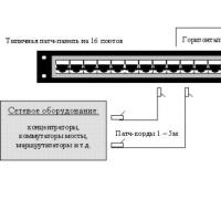 Where are the boundaries between these categories of consumers?
 What is an asset directory
 Free programs for Windows free download